Scientific Components of the Marine Animal Mortality Response Program

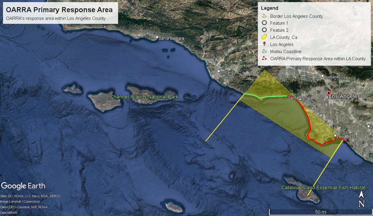
OARRA’s Response Area
OARRA’s primary area of marine animal mortality response is Los Angeles County, California. The response area of Los Angeles County borders 70 miles (110 km) of coast on the Pacific Ocean. The Los Angeles River, Rio Hondo, San Gabriel River, and Santa Clara River flow through Los Angeles County and into the marine environment. LA County and, therefore, OARRA’s response area has the largest population of any county in the United States, 10.11 million people, of which 40% live within 20 miles of the coastline. 43 miles of the response area includes the Ports of Los Angeles and Long Beach, featuring the busiest cargo container port in the western hemisphere, an active cruise ship industry, and heavy recreational use.


Location of Los Angeles County within the state of California.

Los Angeles County, California; OARRA's response area in the yellow overlay.
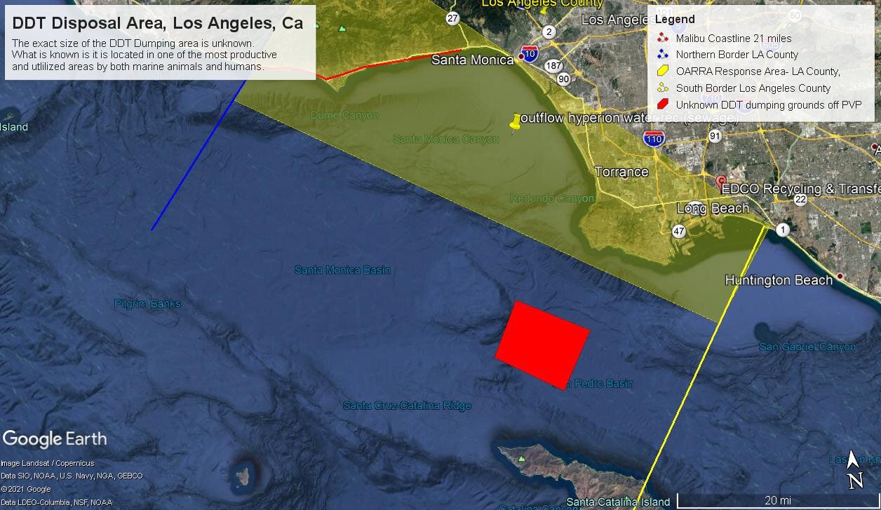
Some of the visible human influences the marine animals encounter within OARRA's response area.
Why?

Historically, deceased marine animals, floating or stranded, were rarely reported or responded to unless they were of significant value, e.g., rare, tagged, or having signs of human interaction. This lack of reporting has led to a significant loss of critical baseline data on these underreported marine animal mortalities and impacted management.
OARRA’s dedicated marine animal mortality program will assure the capture of this critical information. OARRAs program will lead to the overall understanding of why the animal died and a clearer understanding of the threats to both animals and the overall ocean health. The consistent collection of valuable data and analysis will aid in detecting threats to the environment and marine animal populations before they become an emergency.
The data OARRA is collecting by examining these tragic mortalities is used to understand:
Cause of death
Seasonal distribution,
Natural history,
Population health,
Environmental contaminant levels,
Incidents of human interaction,
and incidence of disease.
Beyond the cause of death, the biosurveillance and baseline health research OARRA conducts, while not “emergency response,” assists in providing context during health emergencies. When shared with other Scientists, this information may help predict and prepare for when and where future events may occur and lead to a clearer understanding of overall ocean health.
Okay But How???

Collection of Data
OARRA accomplishes the above, by starting with the meticulous collection of information on many levels. The level of information collected is dependent on the condition of the remains of the marine animal mortality. These conditions are classified into condition codes 1-5. Based on the code, the information OARRA can collect from each tragic mortality for accurate analysis is broken down into Levels of Data, A-C.
Level A Data:
The minimum basic information collected on all marine animal mortalities and condition codes (1-5) is known as LEVEL A Data and includes:
7. Length of animal
8. Sex of animal
9. What tissues or specimens were collected
10. Signs of Human Interaction
11. Disposition of animal
12. Any personal observations
Date
Location
Latitude and Longitude
Species
Condition of animal
Estimated age of animal (class)

A deceased sub-adult male sea lion (Zalophus californianus) awaiting examination by OARRA staff.

OARRA Staff measuring the length of an elephant seal pup (Mirounga angustirostris) for morphometrics.

OARRA Staff collecting a skin sample, used for genetic analysis, from a juvenile elephant seal (Mirounga angustirostris).

Digging Deeper:
Level B and C Data Collection
Supplementing the Level A Data, Level B and C Data includes important data pertaining to the stranding event and life history data.
Level B Data:
Weather and tide conditions, offshore
Human/predator/prey activity
Morphometrics
Post mortum health assessments
Life history samples:
skin
teeth
jaw
status of:
reproductive organs
stomach
intestinal contents, etc.
Level C Data:
Detailed data and results from tissues collected for
Histopathology
Toxicology
Microbiology
Virology
Parasitology
Harmful algal blooms (HAB’s)
Genetics
Life history
Archival
Finishing Up…
The Outcomes:
OARRA’s biosurveillance and baseline health research on marine animal mortalities are important components of the program. Through these efforts, OARRA can determine:
Causes of Death/Human Interaction
How the information is being used:
Monitoring population dynamics
Emerging diseases
Disease prevalence
Ongoing efforts to evaluate and mitigate large whale ship strike risk
Document entanglements
How to reduce future entanglement risks
Carcass disposal options
Environmental impact of disposal
Contaminants
How the information is being used:
Track overall contaminant trends in the environment
Evaluate options for disposal of contaminated marine mammals
Better understand how contaminants affect reproduction and mortality in wild marine mammal populations
Harmful Algal Blooms:
Just as human consumers of seafood contaminated with biotoxins of algal origin are at risk, animals at higher levels of the marine food web, such as marine mammals, are impacted by HABs.
How the information is being used:
Better understand the impacts of HAB toxins on marine mammals, including:
Role in mortality
sub-lethal effects.
cause of mass strandings
UME’s
Precursor warning to humans
This data provides information necessary to detect elevated stranding rates and other trends that may have management and conservation implications. Recording data on gross mortalities may serve as an indicator that a particular population is impacted, threatened, or at increased risk.
When provided in a timely manner, this information may aid in dynamic management practices. Stranding data provide an important baseline for detecting and monitoring the impacts of environmental phenomena, such as El Niño and harmful algal blooms (HABs).
Scientists and natural resource managers use the information in these forms to help promote the management and conservation of marine mammal species and respond to and mitigate threats to marine mammal populations.
